TECHGEA Geophysics
Techgea is a service company specialized in non-invasive methods for the exploration of the subsoil and the non-destructive diagnostics of structures and civil engineering works.
With a qualified team of geologists and engineers, Techgea operates both in Italy and abroad with independent organizational skill.
It is addressed to public bodies, production and service companies, construction companies, to professionals (engineers, geologists and architects).
In order to ensure the best service to its customers, in January 2013 Techgea Srl has obtained the certification of Quality Management System complies with the requirements of ISO 9001:2008 in relation to the following scope: "Design adn survey of geophysical, geognostic environmental and geotechnical investigation" . The certificate was issued by the accredited body Bureau Veritas Italy SpA.
Fields of application
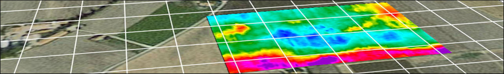
- Geological Exploration (near surface and medium-depth geological modeling for civil works, tunneling, mining).
- Hydrogeological Exploration (water springs analyses, water wells siting, geophysical imaging for hydrogeological modeling).
- Environmental geophysics (location of illegal waste disposals, evaluation of contaminated areas, location of sources of contamination, leachate location in landfill).
- Location of underground structures (underground storage tanks, electrical cables, tunnels, foundational structures).
- Location of natural caves or artificial cavities.
- Investigations for non-destructive archaeological research (buried archaeological remains, diagnostics of monumental works).
- Road inspection
- Diagnostics of civil engineering works (verification of masonry, reinforced concrete structures for the location of reinforcing rods, check the lining of tunnels, assessing the presence and length of pile foundations, etc..).
- Geomembrane lining integrity detection.
- Seismic site classification.
Operating modes
- Design of geophysical survey according to the customer requirements.
- Strong attention the safety of workers on site and in the respect of the land.
- Great accuracy during survey operations and data processing.
- Large experience maturated in hundreds of projects in many countries in hard terrain conditions.
- Constant upgrade of the geophysical equipment and processing software.
- Collaboration with scientific universities for a continuous improvement.